Shutlingsloe, Macclesfield Forest, Gritstone Trail, Oakenclough
3 Hr 1mins
6.91 miles (11.12 Km)
Layby 400 mtrs north of Crag Inn, opposite bridge
SJ983687
From layby head towards Crag Inn and after 100 mtrs, turn right up tarmac track, signposted footpath.
Continue uphill, over cattlegrid and before next gate/wall, take footpath on left uphill (signposted).
Follow the well defined path uphill which leads you to the south end of Shutlingsloe and then up to the trig point.
Take the slabbed path from the trig point over the moor towards Macclesfield Forest.
Through gate into forest, turn left signposted “Langley”.
Drop down to the bridleway and turn left again signposted “Trentabank”.
At the fork, turn left uphill on cycletrack signposted “Forest Bridleway” (beware of bikes!).
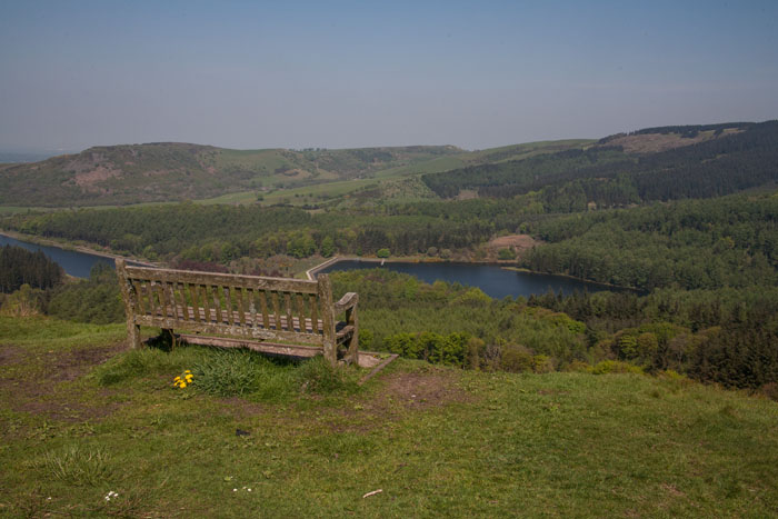
Uphill and along to the viewpoint which makes the slog up to Shutlingsloe worth the effort!
Continue from the viewpoint but don't take the dedicated cycle track off right; take the wide track left.
Continue downhill to the road.
Left onto the Quiet Lane, which turns left uphill after a short distance.
Follow the lane uphill for approx 0.5 Km and then take the 1st narrow lane right (not the farm track).
Downhill past Lees House Farm on the right then after 100 mtrs, take the steps on the left to metal gate. This is the Gritstone Trail.
Follow the Gritstone Trail sign past the house on your left and beyond holiday cottages on your right, the path bears right slightly uphill to a gate.
Pass the barn on your left and at next gate, trend slightly uphill to waymarker in the dip.
Path is slightly less well defined here but continue in same direction aiming for a row of small trees and another waymarker.
From there head up to the style and road ahead.
Left onto road and uphill to where road bends to the left, at which point take the path up steps on the right.
Pass house on your right, through several metal gates and up to the Hanging Gate pub at the top.
Cross road at pub and take the path opposite uphill to a style.
Turn right over the style, through the farm gate and turn immediately left and follow path keeping wall on your left.
Continue directly ahead when wall ends and after a pond on your right, the path turns a sharp right.
Follow to a gate looking across at Oakenclough.
Down to another gate and turn right onto track heading away from house then after 10 mtrs take the path on your left.
The path crosses the stream after a short distance then follow the stream downhill.
Over the wooden bridge avoid the track heading left uphill but continue following stream down to road at bottom.
Turn left on road, uphill to begin with and where road levels out, take track off left by cluster of large trees.
Follow this round a series of bends for approx 500 mtrs and approx 50 mtrs after you see a gate on your left to access land, take the path on your right.
This path is not always well defined but the path bears away from the farm track you were on, trending slightly downhill to begin with then levels out.
This continues over styles and through gates until a sign at a gate points diagonally rightwards downhill.
Follow the path between the gorse bushes down to the road.
Left onto the road, past the Crag Inn and back to the car.


Site by Ged